
I often end up driving to customers during rush hour here in San Jose and it’s madness. I try to calculate driving time but the estimated journey time at 11am is nowhere near the same as at 5pm. Is there a solution with Google Maps on my iPhone?
Starting with driving directions that offered no estimate of how long your journey would actually take, navigational systems have gained enormously in sophistication and it’s astonishing how well they can now route you around traffic and construction. They can even indicate how much extra time the accident a mile ahead is going to add to your journey. This is done by having millions of data points – we’re all reporting our location and transit information as we move around – but also by having a huge dataset of historical traffic information too. It’s a lot of data to sift through, but it’s surprisingly easy to compare a drive from, say, San Mateo to Monterey at 4.30am on a Sunday versus 4.30pm on a Friday afternoon.
Google Maps offers both the ability to specify when you want to leave and, even more interestingly, when you want to arrive, and then uses historical data to estimate your arrival / departure time (depending on which other time you specify). If I want to arrive at 5.00pm exactly, it can recognize that there’s going to be more traffic than usual at that time of day and give me a departure time that compensates. Pretty dang impressive tech, really. Let’s have a closer look.
DRIVING DIRECTIONS IN GOOGLE MAPS
I’m sitting at a coffee shop in Broomfield, Colorado and need to get to the Beyond the Mountain brewpub in Boulder, about 10 miles away. A search for “Beyond” in Google Maps on my iPhone running iOS 15.6 shows that as one of my options:
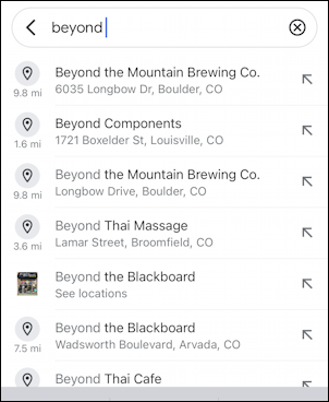
It’s that first one, and even without leaving the search tool, you can see that it’s 9.8 miles away, while Beyond Components is only 1.6mi away and Beyond Thai Massage? Well, if I were intending to head there, it’s only 3.6 miles away.
A tap on “Beyond the Mountain Brewing Co.” and I get confirmation of the location and more information on the venue:
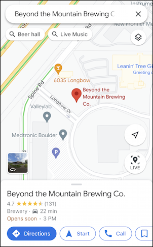
4 1/2 stars? Opens soon? 22 minutes by car? All of that’s tucked onto the very bottom of the view. To get directions, all I need to do is tap on the big blue “Directions” button. Easy enough.
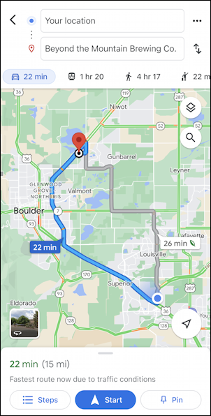
22 minutes at 3pm. Okay. But what if I don’t need to get there until 5pm instead of 3:22pm?
HOW TO SPECIFY DEPARTURE OR ARRIVAL TIME
Tap on the “•••” on the top right of the screen and a menu of options appears that you’ve probably never noticed:
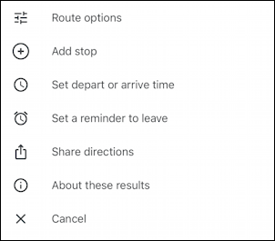
You can specify route options, like no tollways, add a stop, share directions, etc, but what we want is the third choice: “Set departure or arrive time” [not sure why it’s not “arrival” time, but that’s another story entirely]. Choose that option and you’ll be able to choose and specify, as desired:
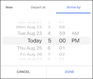
Now Google Maps can work backwards since it knows where I am now, where I want to go and when I want to arrive. A moment or two later here’s what it displays:
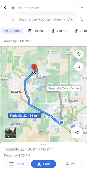
Not too bad, our 22min journey has now changed to 26 minutes, though it’s suggesting a 4:25pm departure, which actually suggests it’s estimating a transit time of 35 minutes, almost double the no-traffic transit. It’s trying to ensure that we’ll make it on time even if it’s bad traffic. Fair enough, arriving a few minutes early is always better than a few minutes late.
Swipe up to show the turn-by-turn directions. There’s an option on the bottom that you’ll love:
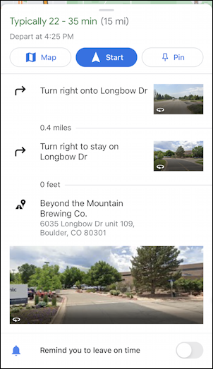
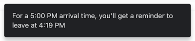
Choose “Remind you to leave on time” and you’ll get a reminder on your phone when it’s time to jump in the car and head to your destination:
That’s all pretty dang cool. Did you know Google Maps could do that?
Pro Tip: I’ve been writing about the iPhone and iOS since the very first iPhone was released. I’ve also owned every major iPhone model! Please check out my iPhone help articles while you’re visiting. Thanks!