
My daughter’s working on a project for school and the teacher has them using Google Earth to measure landmarks. I can’t help wonder: Is that even remotely accurate or is it just a waste of their time?
Satellite imagery has come a long way since the heydey of the Cold War, with experts peering at photos of land masses with a loupe. Now it’s not only all digital but it’s really well encoded for additional information like altitude (critical for measuring distances on the surface: How far is it from the satellite that captured the image?) and, of course, precise latitude and longitude. Not only that, but a version of all this imagery is available online for free through services like Google Earth.
A fair amount of this imagery can be years out of date, so checking out that new construction project across town is probably going to be a fail, but in terms of landmarks and areas that have been developed for many years, it’s an absolute win. While Google Earth tends to work better with the app – and better on mobile – you can easily use the Web-based version accessible at earth.google.com to quick check some measurements. So let’s do that!
FIND A LOCATION IN GOOGLE EARTH
The first step is to know how to search for a location. To do that, you’ll want to familiarize yourself with the basic options all stacked up on the left side of the window. Consider this image:
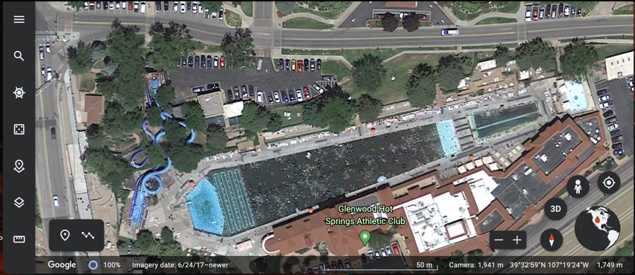
This is the Glenwood Hot Springs Pool, the largest outdoor hot springs pool in the world. How long is it? We’ll get there. First, know that if you click on the magnifying glass icon on the top left you can type in the name of a place anywhere in the world, from the Carrousel de la Tour Eiffel in Paris, France to Qiongdao Island in Beijing, China, False Bay Seal Island Reserve in Cape Town, South Africa to Deadhorse Airport in Alaska, USA. Or you can search for “Glenwood Springs pool” and find where I’m looking!
Top to bottom, the left icons are: three-lines gets you to a more understandable menu of choices, the magnifying lens offers a search feature, the compass wheel is Google Earth Voyager. Click it to find out what it does! Below that the die is “I feel lucky” and will take you to a random spot on the planet. The pin icon lets you remember a spot, but the Web version of Google Earth has this weird ‘projects’ feature so you won’t be able to use that to just remember a spot. The mobile and app versions are a lot more logical in this regard. Finally, the square over another square icon lets you adjust which layers of information are shown, and, finally, the tiny ruler is how you access distance measurement. A lot!
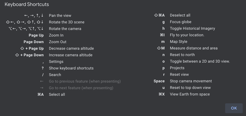
Along the bottom, by the way, you can see where the images came from, (usually) the date of the image (this one’s from 6/24/2017), a scale, the camera “height”, latitude and longitude, and, on the right corner, another set of view controls. You’ll also want to press “?” to get a display of keyboard shortcuts:
But… let’s get back to that measurement.
HOW TO MEASURE DISTANCES IN GOOGLE EARTH
With both end points of the monument or object in question visible, click on the ruler icon on the left side. When you move your cursor around on the map, you’ll now see this:
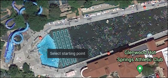
Can you see the “Select starting point”. I’m going to move my cursor to the very left edge of the pool, the “deep end”, as it happens, and click.
Then I can move the cursor and it’ll extend a line from that point to the new cursor position:
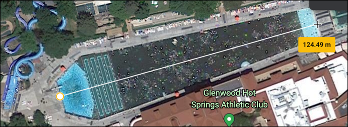
So, how accurate is this 124.49 meters distance? Well, according to the Hotsprings Pool Fact Sheet, the large pool is “405 feet long x 100 feet wide (123 x 30 meters)”. 123 meters official, 124.49 through Google Earth. That’s pretty dang accurate if you ask me!
But let’s try a second monument, one that more people might have familiarity with: The Reflecting Pool at the Lincoln Memorial on the National Mall in Washington, D.C.
HOW LONG IS THE REFLECTING POOL AT THE NATIONAL MALL?
The first step, use the magnifying lens search to zoom across the country to Washington DC:
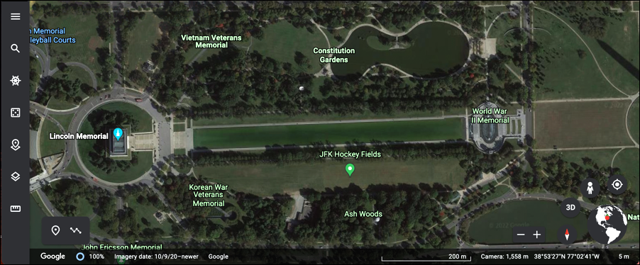
It’s hard to see in this photo, but the long green rectangle in the middle, stretching from the Lincoln Memorial to the World War II Memorial, is the reflecting pool. In person, it always is a beautiful deep blue, but from space? Apparently, it’s green.
Click on the ruler icon on the left side, then position the cursor on the left edge of the pool:
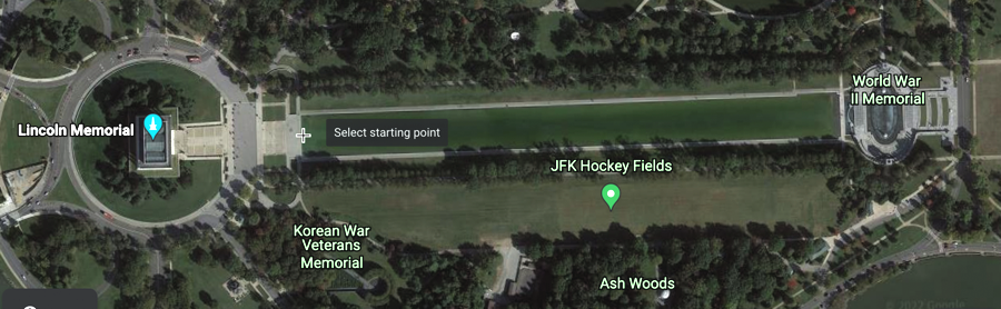
Again, once you’ve clicked, simply move the cursor to the other edge of the pool and click:
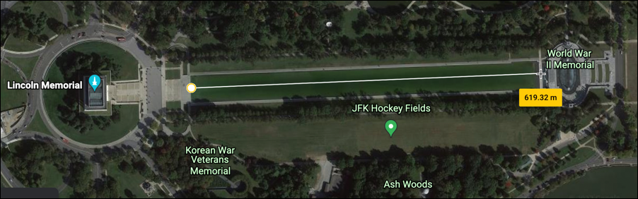
Okay, so Google Earth says 619.32 meters. Now, how long is the actual Reflecting Pool on the National Mall? Almost exactly that length! Designed by Henry Bacon and built back in 1922, it’s “approximately 2,030 feet (620 m) long and 167 feet (51 m) wide”.
You asked in the beginning how accurate Google Earth is and here’s your answer: Incredibly accurate, particularly on larger features. It’s rather astonishing how accurate it is, estimating the Reflecting Pool to be 619.32m when it’s actually 620m long!
Pro tip: I’ve been writing about Internet, Web, and computing basics for quite a few years now and have amassed an enormous library of free help tutorials and guides. Why not check out my Computing Basics Library for more useful and interesting tutorials while you’re here? Thanks!
Thanks